|
Friday July 08, 2005___ 1:15 P.M.
C. S. T.
By Kenneth Martin
Scientists Get a Real "Rise" Out of Breakthroughs in
How We Understand Changes in Sea Level
NASA Satellites Measure and Monitor Sea Level
- Update
For the first time, researchers have the tools
and expertise to understand the rate at which sea
level is changing and the mechanisms that drive that
change.
Sea levels rise and fall as oceans warm and cool
and as ice on land grows and shrinks. Other factors
that contribute to sea level change are the amount
of water stored in lakes and reservoirs and the
rising and falling of land in coastal regions.
"From the Mississippi Delta to the Maldives Islands
off the coast of India to the multitude of other
low-lying coastal areas around the world, it’s
estimated that over 100 million lives are
potentially impacted by a three-foot increase in sea
level," said Dr. Waleed Abdalati, head of the
Cryospheric Sciences Branch at NASA’s Goddard Space
Flight Center, Greenbelt, Md. "This is an ideal
time, during the midst of an historic year of both
related natural events and research developments
tied to this critical global issue, to talk to the
public about whether ice in our polar regions is
truly melting, whether our oceans are indeed rising
faster, and what these changes may mean to us."

Image Left:Oceans
change. Beyond merely the sloshing of waves that we
all recognize along the beaches of the world, sea
level describes a complex array of conditions, from
chemistry to temperature to changes in the shape of
the basins that hold the world's water. In this
visualization, we look at changes in sea level
measured from space using data from the TOPEX/Poseidon
and Jason satellites.
Click here to view this .mpg animation. Click on
the image to open a high resolution image. Credit:
NASA
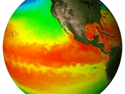
Image Right:Sea
surface temperature plays a vital role in the
behavior of the Earth's climate and weather. It is
both a causal factor and a resulting effect of
complex interactions of natural forces on Earth.
NASA not only measures sea surface temperature from
space using powerful scientific instruments, but it
also studies temperature processes in advanced
computer models, as shown in this animation.
Click here to view this .mpg animation. Click on
the image to open a high resolution image.
Credit: NASA
NASA is taking advantage of its unique
space-based satellite observations of Earth’s oceans
and atmosphere, in combination with satellite
observations and sea surface measurements from
domestic and international partners, to learn more
about why and how the world’s waters are rising. In
doing so, the agency is hoping to determine more
about factors leading to sea level change,
indicators of change such as ocean expansion,
changes in ice, impoundment of water, and movement
of Earth and coastal regions, and how the latest
research developments contribute to our knowledge of
sea level rise.
NASA is working with NOAA, the National Science
Foundation, and others to explore and understand sea
level change -- to tell the story of what is
happening. NASA focuses on developing ways to look
at sea level change using data from NASA satellites
and aircraft instruments, as well as ground and air
observations and ocean measurements from partners.
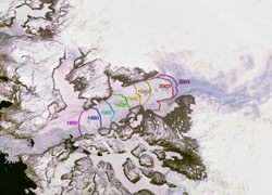
Image Left:
Since measurements of Jakobshavn Isbrae were first
taken in 1850, the glacier has gradually receded,
finally coming to rest at a certain point for the
past 5 decades. However, from 1997 to 2003, the
glacier has begun to recede again, this time almost
doubling in speed.
Click here to view this .mpg animation. Click on
the image to open a high resolution image.
Credit: NASA
NASA satellite missions devoted to sea level
research include: the Gravity Recovery And Climate
Experiment (GRACE), which maps Earth’s gravitational
field with precision and resolution, and whose data
helps us better understand movement of water
throughout the Earth; the Ocean TOPography
Experiment (TOPEX/Poseidon), a joint U.S./French
satellite that uses radar to map the precise
features of the oceans’ surface; Jason, which
measures ocean height and monitors ocean
circulation; and the Ice, Cloud and Land Elevation
Satellite (ICESat), whose primary purpose is to
study the mass of polar ice sheets and their
contributions to global sea level change.
According to Dr. Laury Miller, Chief of the NOAA
Laboratory for Satellite Altimetry in Washington,
the big news that has emerged over the past few
years is that the rate of 20th Century sea level
rise is about two millimeters per year and that only
a quarter of this is due to expansion caused by
warming of the oceans. This provides an important
context for these recent observations.
“We’ve found that the largest likely factor for sea
level rise is changes in the amount of ice that
covers Earth. Three-fourths of the planet’s
freshwater is stored in glaciers and ice sheets, or
about 220 feet of sea level," said Dr. Eric Rignot,
Principal Scientist for the Radar Science and
Engineering Section at NASA’s Jet Propulsion
Laboratory in Pasadena, Calif. Research results by
Rignot and partners, published in an October 2004
article in Science Magazine, further offer evidence
that ice cover is shrinking much faster than
thought, with over half of recent sea level rise due
to the melting of ice from Greenland, West
Antarctica’s Amundsen Sea, and mountain glaciers.


Images Above:
While space based measurements are the only way to
accurately measure global ocean conditions,
complimentary measurements can be taken from floats
distributed around the world. The Argo project, an
international mission, will launch 3000 floats,
which will deliver salinity, column temperature, and
current velocity information. Image Left: Detail of
one of the buoys.
Click here to view this .mpg animation. Image
Right: A buoy floating at sea.
Click here to view this .mpg animation. Click on
the images above to open a high resolution image.
Credit: NASA
The latest sea level research conducted by Dr.
Steve Nerem, Associate Professor, Colorado Center
for Astrodynamics Research at the University of
Colorado in Boulder, and his colleagues, published
in a 2004 issue of Marine Geodesy Journal, has found
that recent TOPEX/Poseidon and Jason satellite
observations show an average increase in global mean
sea level of three millimeters a year from
1993-2005. This rate is more than 50 percent greater
than the average rate of the last 50 years.
"Now the challenge is to develop an even deeper
understanding of what is responsible for sea level
rise and to monitor for possible future changes.
That's where NASA’s satellites come in with global
coverage, and ability to examine the many factors
involved," said Miller.
Related Links:
+ Main Media Page for the NASA Science Update
+ Access to Recent Breakthroughs from Peer-Reviewed
Journal Papers |